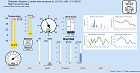
River Heights

Last Updated: Tuesday April 30th, 2024 01:00 PM CDT

Stage Color Key
No Flooding Near Flood Minor Flooding Mod Flooding Major Flooding Obs > 24hrs

Location HeightTrendForecastStatus
Cimarron River near Guthrie (GTRO2) 7.45ft Rising at 0.05 ft/hr  Normal
Cimarron River near Dover (DOVO2) 11.81ft Falling at 0.05 ft/hr  Normal
Cimarron River near Waynoka (WANO2) 5.68ft No change in last hour  Normal
Eastern Oklahoma Lakes at Kaw Lake (KAWO2) 1,014.32ft Rising at 0.01 ft/hr  Not Defined
Arkansas River at Ralston (RLSO2) 7.66ft Falling at 0.1 ft/hr  Normal
North Canadian River at Oklahoma City (OKBO2) 5.27ft Falling at 0.01 ft/hrExpected to fall 0.01 ft. in next hour
Normal
Cottonwood Creek near Seward (SWDO2) 3.48ft Rising at 0.01 ft/hr  Normal
Eastern Oklahoma Lakes at Keystone Lake (KEYO2) 721.75ft Rising at 0.02 ft/hr  Not Defined
Arkansas River at Tulsa (TLSO2) 4.61ft Falling at 0.01 ft/hr  Normal
Polecat Creek near Jenks (JNKO2) 3.39ft Falling at 0.04 ft/hr  Normal
Bird Creek near Sperry (SPEO2) 2.15ft Rising at 0.02 ft/hr  Normal
Arkansas River near Haskell (HSKO2) 5.90ft Falling at 0.03 ft/hr  Normal
Deep Fork River near Beggs (BGSO2) 7.44ft Falling at 0.18 ft/hrExpected to fall 0.05 ft. in next hour
Normal
Arkansas River near Muskogee (MKGO2) 20.85ft Falling at 0.05 ft/hrExpected to fall 0.06 ft. in next hour
Normal
Eastern Oklahoma Lakes at Tenkiller Lake (TENO2) 634.52ft Falling at 0.01 ft/hr  Not Defined
Eastern Oklahoma Lakes at R. S. Kerr Lock and Dam (KERO2) 459.64ft Rising at 0.03 ft/hr  Not Defined
Illinois River at Gore (GORO2) 13.73ft Falling at 0.01 ft/hr  Normal
Caney River near Collinsville (CVLO2) 8.47ft Falling at 0.01 ft/hrExpected to fall 0.01 ft. in next hour
Normal
Eastern Oklahoma Lakes at Wister Lake (WSLO2) 481.05ft Falling at 0.01 ft/hr  Not Defined
Verdigris River near Lenapah (LEPO2) 27.30ft Rising at 0.08 ft/hrExpected to fall 0.42 ft. in next hour
Normal

Data Courtesy of the Advanced Hydrologic Prediction Service
Script Courtesy of Dennis at East Masonville Weather