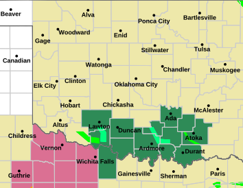
Weather Alerts for Payne CountyIssued by the National Weather Service |
Flash Flood Warning
Flash Flood Warning
| |
||
| PAYNE COUNTY | ||
Areas Affected: Kingfisher, OK - Lincoln, OK - Logan, OK - Payne, OK |
||
| Effective: Tue, 5/7 12:31am | Updated: Tue, 5/7 1:21am | Urgency: Immediate |
| Expires: Tue, 5/7 4:15am | Severity: Severe | Certainty: Likely |
Details:
FFWOUN

The National Weather Service in Norman has extended the

* Flash Flood Warning for...
Southeastern Kingfisher County in central Oklahoma...
Northern Lincoln County in central Oklahoma...
Southern Logan County in central Oklahoma...
Southern Payne County in central Oklahoma...

* Until 415 AM CDT.

* At 1231 AM CDT, Heavy rain is moving out of the warning area, but
up to 3 inches of rain have fallen. Flash flooding is already
occurring. Portions of Highway 177 near and north of Carney are
flooded.

HAZARD...Life threatening flash flooding. Thunderstorms
producing flash flooding.

SOURCE...Emergency management reported.

IMPACT...Life threatening flash flooding of creeks and streams,
urban areas, highways, streets and underpasses.

* Some locations that will experience flash flooding include...
Guthrie, Cushing, Perkins, Stroud, Langston, Yale, Okarche,
Cashion, Carney, Tryon, Ripley, Agra, Coyle, Cedar Valley,
Cimarron City, Kendrick, Meridian, Avery, Quay and Parkland.
Information: Turn around, don't drown when encountering flooded roads. Most flood deaths occur in vehicles. Be especially cautious at night when it is harder to recognize the dangers of flooding. Be aware of your surroundings and do not drive on flooded roads. |
||
| |
||
| PAYNE COUNTY | ||
Areas Affected: Blaine, OK - Kingfisher, OK - Logan, OK - Noble, OK - Payne, OK |
||
| Effective: Tue, 5/7 12:15am | Updated: Tue, 5/7 1:21am | Urgency: Immediate |
| Expires: Tue, 5/7 2:15am | Severity: Severe | Certainty: Likely |
Details:
At 1215 AM CDT, Doppler radar indicated thunderstorms producing
heavy rain across the warned area. Between 1 and 3 inches of rain
have fallen. Additional rainfall amounts up to 1 inch are possible
in the warned area. Flash flooding is ongoing or expected to begin
shortly.

HAZARD...Flash flooding caused by thunderstorms.

SOURCE...Radar.

IMPACT...Flash flooding of small creeks and streams, urban areas,
highways, streets and underpasses as well as other poor
drainage and low-lying areas.

Some locations that will experience flash flooding include...
Stillwater, Kingfisher, Crescent, Glencoe, Dover, Mulhall,
Cimarron City, Orlando, Lovell, Lake Carl Blackwell and Lake
Mcmurtry.
Information: Turn around, don't drown when encountering flooded roads. Most flood deaths occur in vehicles. Be especially cautious at night when it is harder to recognize the dangers of flooding. |
||
| |
||
| PAYNE COUNTY | ||
Areas Affected: Kingfisher - Logan - Payne - Oklahoma - Lincoln - Cleveland - Pottawatomie - Seminole - Hughes - Pontotoc - Coal |
||
| Effective: Tue, 5/7 12:35am | Updated: Tue, 5/7 1:21am | Urgency: Future |
| Expires: Tue, 5/7 7:00am | Severity: Severe | Certainty: Possible |
Details:
* WHAT...Flooding caused by excessive rainfall continues to be
possible.

* WHERE...Portions of central, east central, and southeast Oklahoma,
including the following counties, in central Oklahoma, Cleveland,
Kingfisher, Lincoln, Logan, Oklahoma, Payne and Pottawatomie. In
east central Oklahoma, Pontotoc and Seminole. In southeast
Oklahoma, Coal and Hughes.

* WHEN...Until 7 AM CDT this morning.

* IMPACTS...Excessive runoff may result in flooding of rivers,
creeks, streams, and other low-lying and flood-prone locations.
Storm drains and ditches may become clogged with debris.

* ADDITIONAL DETAILS...
- Storms producing heavy rain, or continued flooding from
previous rains possible overnight.
- http://www.weather.gov/safety/flood
Information: You should monitor later forecasts and be alert for possible Flood Warnings. Those living in areas prone to flooding should be prepared to take action should flooding develop. |
||


