| |
Today |
Yesterday |
| High |
77.1°F
@ 5:48pm |
81.8°F
@ 1:54pm |
| Low |
61.8°F
@ 7:45am |
64.4°F
@ 11:58pm |
Sta* High
88.1°F
2020 |
Sta* Low
46.2°F
2019 |
|
* This Station's Records Since 1/2012 |
|
|

|
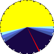
Night time, Dry, Clear skies
|

|
Wind:
NNW
0.0
Gusting to:
0.0 mph
|
 |
Rain:
0.20 in
|

|
Current CBI
Fire Danger:
-0.7 of 100
|
|
Tonight

Mostly Clear
|
Monday

Sunny
|
Monday
Night
Mostly Clear
|
Tuesday

Sunny then Slight Chance Showers And T-Storms
|
Tuesday
Night

Chance Showers And T-Storms
|
Wednesday

Chance Showers And T-Storms
|
Wednesday
Night

Chance Showers And T-Storms
|
|
Lo 53°F |
Hi 81°F |
Lo 59°F |
Hi 87°F |
Lo 65°F |
Hi 86°F |
Lo 65°F |
 7 Day Forecast Details 7 Day Forecast Details
|
|
| Dew Point |
Liquid Precipitation |
Wind Speed |
Sun/Moon |
| Current: |
 61.9°F
|
| Last Hour: |
-1.3°F
|
| High 3:40 PM: |
64.7°F
|
| Low 9:16 AM: |
59.1°F
|
| Record High: |
86.0°F on
Aug-5-2023 |
| Record Low: |
-11.7°F on
Jan-14-2024 |
| Wetbulb: |
63.4°F
|
|
Rain Today
|
|
Today:
|
0.20 in
|
| Storm Rain: |
0.82 in
|
| Yesterday: |
0.63 in
|
| Last 7 Days: |
0.83 in
|
| Apr Rain: |
2.33 in
|
Apr to Date
Avg:10
|
0.00 in
|
Apr to Date
Diff from Avg:10
|
 2.33 in 2.33 in
|
| Apr Avg: |
0.13 in
|
| Diff from Avg: |
2.20 in
|
| Season:1 |
5.30 in
|
YTD
Avg:11
|
1.53 in
|
YTD
Diff from Avg:11
|
3.77 in
|
Last Rain
Time/Date: |
Apr-28-2024
at 9:17 PM |
|
27 rain days in 2024 |
9 days in April
0 days since last rain |
|
| Current: |
NNW
0.0 mph
|
| 1Hr Average: |
Calm |
| Wind Run: |
75.02 miles
|
|
Wind Gust |
| Current: |
0.0 mph
|
| Today: |
22.0 mph 2:06 AM
|
| Month: |
34.0 mph
Apr-6 |
| Year: |
34.0 mph
Apr-6 |
| Record Gust: |
34.0 mph
Apr-6-2024 |
|
Sunlight:
13 h 36 m 52 s
of Sunlight Yesterday
13 h 38 m 53 s
of Sunlight Today
Which is
2 min 1 sec longer than
yesterday
13 h 40 m 53 s
of Sunlight Tomorrow
(Noon ?>)
 (Midnight
|
|
Waning Gibbous
|

|
74%
Illuminated |
|
| Humidity |
Barometer |
| Current: |
88%
|
| Last Hour: |
6% |
| High 1:06 AM: |
92% |
| Low 5:49 PM: |
61% |
| Record High: |
96%
Jan-24-2024 |
| Record Low: |
18%
Feb-21-2024 |
|
| Current: |
29.816 inHg
|
| Last Hour: |
Steady
|
| High 12:09 PM: |
29.837
|
| Low 1:43 AM: |
29.564
|
| Record High: |
30.755 inHg
Jan-20-2024 |
| Record Low: |
29.347 inHg
Jan-8-2024 |
|
|
Cooling Degree Days |
Snow3 |
Heat Index |
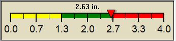
Oklahoma City Air Quality |
| Today: |
0.3 |
| Apr: |
80.8 |
| 2024 to Date: |
108.4 |
|
Heating Degree Days |
| 2024 to Date: |
1474.6 |
|
| Today: |
0.00 in
|
| Yesterday: |
0.00 in
|
| Apr Snow: |
 0.00 in 0.00 in
|
| Apr Avg: |
0.00 in
|
| Diff from Avg: |
0.00 in
|
| Season Total:2 |
0.00 in
|
| Snow Depth: |
0.50 in
|
|
0 snow days in April |
|
0 snow days this season.2
|
Average 1st Snow:
0 |
|
| Current: |
65.7°F
|
| High 5:48pm: |
77.1°F
|
| Yesterday: |
84.9°F
|
| Record: |
127.9°F
Aug-5-2023 |
|
Quality
Index6:
42

Density:
1.20 kg/m3 |
|
| UV Summary/Forecast |
Solar Summary Unavailable |
|
High Today:
7.6 @ 2:21 PM
|
Apr-29

7.1
|
Apr-30
7.4
|
May-01

8.3
|
|
|
| Almanac |
Irrigation Index5 |
Station All Time Records |
Cloud Level
|
| Currently: |
Evening |
| YTD Avg Temp: |
51.4°F
|
| Sunrise: |
06:36 |
| Sunset: |
20:14 |
| Moonrise: |
1:23 am |
| Moonset: |
10:40 am |
| Full Moon: |
Apr-23-2024 |
| New Moon: |
03:23 UTC
May-07-2024 |
|
| Updated at Midnight |
| Current ET: |
0.12 in
|
| 7-Days Rain: |
0.83 in
|
| 7-Days ET: |
1.11 in
|
|
7-Day: |
0.28 in
|
|
April: |
1.9 in
|
| Support this Site! |
|
Your donation helps support this site
|
|
| HIGHS: |
LOWS: |
104.7°F
Aug-3-2023 |
-1.1°F
Jan-15-2024 |
| Daytime Records |
103.6°F°F
Aug-03-2023 |
4.1°F°F
Jan-14-2024 |
| Nitetime Records |
88.9°F°F
Aug-04-2023 |
1.6°F°F
Jan-15-2024 |
ICN:4 | S3C2:6 | Ajax 3.07
ISS:Ok | CON:4.7 | RCP:99% |
|

|


